Town · Shropshire, England

Wroxeter

Roman name: Viroconium

Beside the Severn, a fortress for five thousand legionaries became a city of 78 hectares, the capital of the Cornovii. Most of it still lies under the fields, and we know its houses without having dug them.

RichboroughLondonBathYorkVindolandaCorbridgeChestersHousesteadsBirdoswaldPortchesterWroxeter
Other dots are the places we cover. Wall lines simplified. Coast: Natural Earth.
Fortress
late 50s AD, 16 hectares1
City founded
the AD 90s
City
78 hectares, 48 blocks
Centre empty
by the mid 5th century
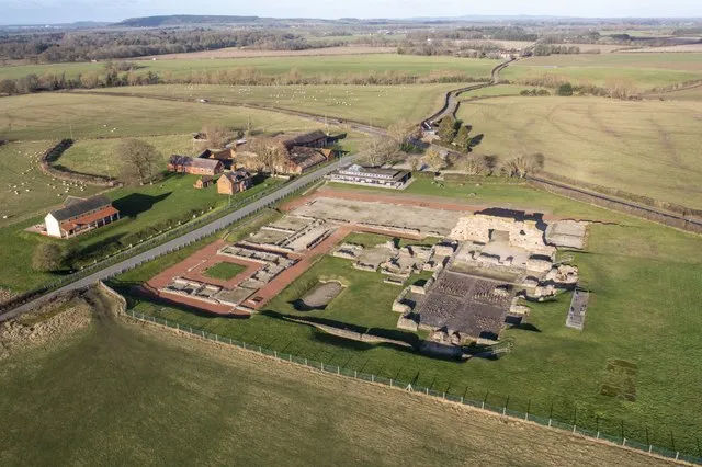
Aerial view of excavated Roman ruins and a reconstructed house among flat fields, with a farm and a road
Wroxeter from the air. The ruins on show are the civic baths in the centre of the city; the rest of the city lies under the fields all around.Photo: TCExplorer, CC BY-SA 2.0, via Geograph

The story of Wroxeter

When the Roman army reached the Shropshire plain, people had been farming it for more than 1,500 years. They were the Cornovii. They lived in farmsteads, perhaps in hillforts like the Wrekin too. They used no coins, little pottery apart from containers of salt from the Cheshire brine springs, and probably vessels of leather and wood. Their wealth was in cattle and sheep, and there is no sign that they were warlike.1

The army arrives

The army came in the late 40s AD, about four years after the invasion, and built camps at the river crossings. Around AD 47 a fort for 500 cavalry went up by the ford. The tombstone of one of its riders, Tiberius Claudius Tirintius, shows his unit came from Thrace, now Bulgaria and Greece.1

About ten years later the Fourteenth Legion built a full fortress a kilometre to the north, on high ground above the Severn: room for 5,000 legionaries and 500 cavalry, with workshops, stores, a hospital, baths and a mansion for the commander. Soldiers could not legally marry, but many had partners, local women or women who had followed the legion from Mainz in Germany. A village of families and traders grew up outside the gates.1

For the local people, losing land to the fortress, facing soldiers, money and a new language must have been a shock.1 The Twentieth Legion took over around AD 68. Wales was conquered by 78, the army moved north, and once the legion began a new fortress at Inchtuthil in Scotland, around AD 85, Wroxeter was no longer needed.1

A city on a soldier’s grid

The army flattened the fortress walls but left the streets, and in the 90s a city was laid out on them, probably by local leading families and retired soldiers together. It was planned on a grand scale: 78 hectares and 48 blocks, almost five times the size of the fortress. Probably not all of it was ever filled.1

Its civic centre was finished between AD 130 and 150: a public bath house with a market hall and shops, and across the road the forum, the city’s marketplace, town hall and courts. Around AD 200 the city got a wall, not of stone but of timber and turf, perhaps more for show than for defence.1

The slow end

There was no sack. In the 3rd and 4th centuries the empire paid out more than it raised, and inflation hit city government hard. At Wroxeter the baths grew shabby and part of the forum was abandoned early in the 4th century. Great buildings were taken down when they became unsafe. By the middle of the 5th century the city centre was empty. A small community stayed by the ford, around what became St Andrew’s church, which still lines up with the Roman street grid.1

Where the evidence is unclear

A city or a plan for one?The 48 blocks were marked out, but it is unlikely all were lived in, at least at first. The grid shows ambition more than population.1

Did Christians carry on here?St Andrew’s may have taken over from an earlier British Christian community, the last of the Roman townspeople. The church’s earliest stone is 10th or 11th century, so it cannot be proved.1
How big

The legion’s fortress inside the city that replaced it.

City, 78 haFortress, 16 ha

Blue outline: a football pitch, 105 × 68 m. City: about 109 pitches. Fortress: about 22 pitches.

Each area drawn as a square at the same scale. The real fortress and city had their own shapes.

The fortress of the Fourteenth Legion covered 16 hectares. The city laid out over it covered 78, almost five times as much.1

That is about the area of a hundred football pitches, for a city whose houses we can count, around 240 of them, mostly without lifting a spade.

Wroxeter through time

Fort, fortress, city, village.

  1. AD 47Cavalry fort By the ford, around AD 47.
  2. AD 57Fortress The Fourteenth Legion, about ten years after the fort.
  3. AD 78Wales conquered The campaign base begins to empty.
  4. AD 90City laid out In the 90s, on the fortress streets.
  5. AD 130Forum and baths The civic centre, finished AD 130 to 150.
  6. AD 200Earth wall Around AD 200, of timber and turf.
  7. AD 310Forum half empty Early in the 4th century.
  8. AD 450Centre empty By the middle of the 5th century.
Dated events only, most of them approximate. Red: Roman. Black: after Rome. Spacing is true to time.

What is there today

Photographs by visitors, shared under an open licence.

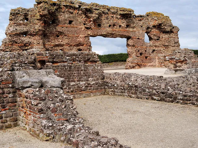
A tall ruined wall of red sandstone and brick with a large opening
The Old Work, a towering piece of the civic baths. The church in the village was built partly with stone robbed from the city.Photo: David Dixon, CC BY-SA 2.0, via Geograph
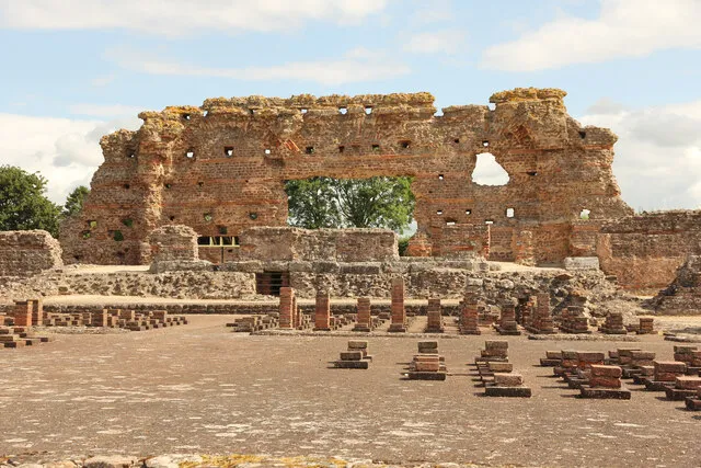
Rows of short brick stacks in front of a high ruined wall
The heated rooms of the baths. The brick stacks held up a floor with hot air flowing beneath it.Photo: Richard Croft, CC BY-SA 2.0, via Geograph
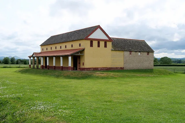
A long yellow-plastered building with a red-tiled roof and a covered porch
A modern full-size reconstruction of a Roman town house, on the site. Around 240 real houses lie under the fields.Photo: David Dixon, CC BY-SA 2.0, via Geograph

Sources for this page

Every number on this page comes from one of these. How we check.

Last reviewed 12 November 2026. Spotted a mistake? Tell us.

  1. White, R. H. History of Wroxeter Roman City. English Heritage. (Honorary Research Fellow, University of Birmingham.) www.english-heritage.org.uk/visit/places/wroxeter-roman-city/history/Used for: Wroxeter: the Cornovii, the fortress, the 78-hectare city and its slow end. Checked 12 November 2026.
  2. Pleiades: a gazetteer of past places. Institute for the Study of the Ancient World, New York University. CC BY 3.0. pleiades.stoa.orgUsed for: Roman names of places and their positions. Checked 12 November 2026.
  3. Natural Earth, 1:110m and 1:50m land, public domain, via the world-atlas package by Mike Bostock (ISC licence). www.naturalearthdata.com/Used for: Every coastline drawn on this site. Checked 11 November 2026.