Town · Northumberland, England

Corbridge

Roman name: Coria

Where the main road to Scotland crossed the Tyne, the army built fort after fort, then a supply base for the whole frontier. Around it grew one of only two real towns near Hadrian’s Wall.

RichboroughLondonWroxeterBathYorkVindolandaChestersHousesteadsBirdoswaldPortchesterCorbridge
Other dots are the places we cover. Wall lines simplified. Coast: Natural Earth.
First fort
about AD 861
Supply base
from the AD 160s
Town
15 to 20 hectares2
Left
early 5th century
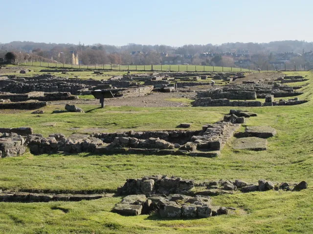
Wide view of low Roman ruins in grass, with a church tower and hills in the distance
The excavated centre of the town from the south-west. Most of Roman Corbridge lies unseen under the fields around it.Photo: Mike Quinn, CC BY-SA 2.0, via Geograph

The story of Corbridge

The first Roman base here was half a mile to the west, at Red House, probably built for Agricola’s campaigns into Scotland between AD 77 and 83. It was given up in about AD 86, perhaps because the river flooded it, and a new fort was built on the present site, a better place for a lasting bridge.1

Fort I burnt down in about AD 105, maybe in an attack. Fort II was part of a new frontier along the Stanegate road and was altered in about AD 122 to support the new Wall. In AD 139 and 140, when the army moved north to build the Antonine Wall, Corbridge was busy again: inscriptions record big new buildings, probably granaries, for the road north.1

A base for the legions

In the early 160s Corbridge changed. Soldiers from two legions, the Twentieth from Chester and the Sixth from York, arrived and built temples and other big buildings. They had two jobs: to help hold the Wall and the outpost forts up the road into Scotland, and to run Corbridge as a store and market for the whole frontier.1

They began a vast square building, now called Site XI, 67 by 65.5 metres, with rooms opening onto a courtyard. It was probably a warehouse and market. The blocks were huge and fitted so tightly that no mortar was used. It was never finished: a fire swept the site, and building never started again. Some link that fire to the invasion across the Wall in the early 180s.12

The town

In the early 3rd century two walled compounds housed soldiers from the legions, and the great granaries were rebuilt in the form you can see. Corbridge was one of the two main supply bases for the emperor Septimius Severus’s war in Scotland, AD 208 to 211.1

A real town grew up around the soldiers. It had a public fountain fed by an aqueduct; the edges of its stone trough are worn down, perhaps by generations of people washing clothes. By the 3rd century it was probably the capital of a self-governing district, though its name for that is lost. The main road through it was still being repaired as late as AD 370. Then, when Roman government collapsed in the early 5th century, the town seems to have emptied quickly.12

Where the evidence is unclear

Who burnt the market hall?The fire is certain; its date and cause are not. The building was begun sometime between about AD 160 and 185. An invasion in the early 180s fits, but nothing proves it.1

Was there a garrison at the end?Soldiers may still have lived in the compounds in the 4th century, but no one knows which unit, and little is known about the town’s walls.1

Treasure hunters

The ruins were a quarry long before they were history. Builders of St Wilfrid’s church at Hexham took stone from here as early as the 670s. King John dug for treasure in 1201 and found only stones “marked with brass, iron and lead”, the metal clamps that once held Roman blocks together. The site was ploughed flat by about 1810. Proper digging began in 1906, and in 1964 archaeologists found a wooden chest buried under Site XI around AD 105 to 120, holding tools, weapons and two suits of plate armour, the best preserved ever found.1
How much you can see

The part on show against the whole town under the fields.

Whole town, at most, 20 haWhole town, at least, 15 haOn show today, 1.8 ha

Blue outline: a football pitch, 105 × 68 m. Whole town, at most: about 28 pitches. Whole town, at least: about 21 pitches. On show today: about 2.5 pitches.

Each area drawn as a square at the same scale. The town’s edge is known from air photographs and digs before 1914, so it is given as a range.

The ruins you can walk around cover about 1.8 hectares. The whole Roman town, known from air photographs and early digging, covered roughly 15 to 20.2

So what you see is the centre and no more: about a tenth of the town, or less.

Corbridge through time

Forts, base, town, quarry.

  1. AD 86Fort I About AD 86, at the river crossing.
  2. AD 139Granaries AD 139 to 140, for the move to the Antonine Wall.
  3. AD 208Severus’s war AD 208 to 211: one of two main supply bases.
  4. AD 370Road repaired The last known official works.
  5. AD 675Stone taken For St Wilfrid’s church at Hexham, from the 670s.
  6. AD 1201King John digs Looking for treasure. He finds none.
  7. AD 1810Ploughed flat About 1810.
  8. AD 1964Hoard found A chest of armour and tools under Site XI.
Dated events only. Red: Roman. Black: after Rome. Spacing is true to time.

What is there today

Photographs by visitors, shared under an open licence.

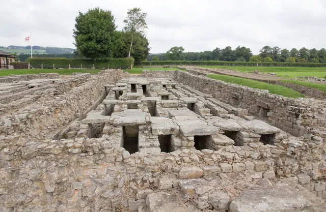
A long stone building with a raised stone floor and gaps for air beneath
One of the two granaries, probably early 3rd century: the best preserved in Britain, with their raised floors and air vents still in place.Photo: David P Howard, CC BY-SA 2.0, via Geograph
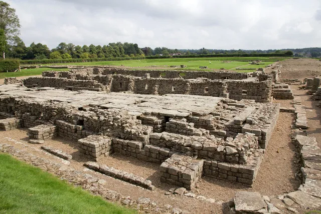
The low stone walls and raised floor of a large Roman granary
The granaries from another side. Columns along the front held up a porch over the loading bays; the road outside rose so much over the centuries that it buried their bases.Photo: David P Howard, CC BY-SA 2.0, via Geograph
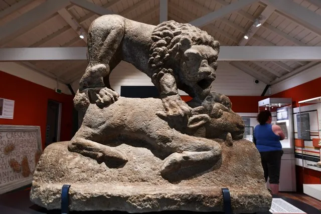
A stone sculpture of a lion standing over another animal, in a museum
The Corbridge Lion, in the site museum: a lion standing over its prey.Photo: Michael Garlick, CC BY-SA 2.0, via Geograph

Sources for this page

Every number on this page comes from one of these. How we check.

Last reviewed 12 November 2026. Spotted a mistake? Tell us.

  1. History of Corbridge Roman Town. English Heritage. www.english-heritage.org.uk/visit/places/corbridge-roman-town-hadrians-wall/history-and-stories/history/Used for: Corbridge: the forts from about AD 86, the legionary supply base, the granaries and the town. Checked 12 November 2026.
  2. Description of Corbridge Roman Town. English Heritage. www.english-heritage.org.uk/visit/places/corbridge-roman-town-hadrians-wall/history-and-stories/history/description/Used for: Corbridge: the size of the town, the roads, Site XI, the granaries and the fountain. Checked 12 November 2026.
  3. Pleiades: a gazetteer of past places. Institute for the Study of the Ancient World, New York University. CC BY 3.0. pleiades.stoa.orgUsed for: Roman names of places and their positions. Checked 12 November 2026.
  4. Natural Earth, 1:110m and 1:50m land, public domain, via the world-atlas package by Mike Bostock (ISC licence). www.naturalearthdata.com/Used for: Every coastline drawn on this site. Checked 11 November 2026.