Fort · Northumberland, England

Chesters

Roman name: Cilurnum

Where Hadrian’s Wall crosses the North Tyne, a fort for 500 horsemen was built straight across it. For more than two hundred years its riders came from northern Spain.

RichboroughLondonWroxeterBathYorkVindolandaCorbridgeHousesteadsBirdoswaldPortchesterChesters
Other dots are the places we cover. Wall lines simplified. Coast: Natural Earth.
Built
about AD 1241
Built for
about 500 cavalry
Longest garrison
the Second Asturians, from Spain
Held until
the early 5th century
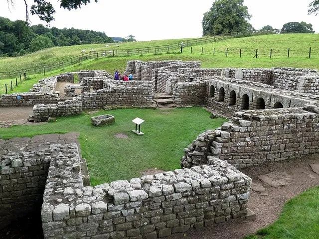
Low stone walls of a Roman bath house with a row of arched niches, in green parkland
The bath house, between the fort and the river. Its excavation in the 1840s turned up many 4th-century coins.Photo: Andrew Curtis, CC BY-SA 2.0, via Geograph

The story of Chesters

When Hadrian’s Wall was begun in AD 122 there were no forts on it. Within two years the plan changed, and 15 forts were added to the line. The first of them were built straight across the Wall, half on each side. At Chesters the builders filled in the ditch in front of the Wall and knocked down a turret they had only just finished, to make room.1

Five hundred horsemen

An inscription from Hadrian’s reign names the first garrison: the ala Augusta ob virtutem appellata, “the cavalry regiment called Augusta for its courage”, about 500 strong. Riders and horses lived under one roof, in stable-barracks. A regiment that size needed 16 of them, each holding about 32 men and their horses.1

The fort sat where the Wall crossed the North Tyne. A bridge carried the Wall over the river, and you can still see the abutment on the east bank.1

Riders from Spain

By AD 178 to 184 at the latest a new cavalry regiment was here: the ala II Asturum, the Second Asturians, first raised in northern Spain. They stayed for the rest of the Roman period. The barracks you can see were rebuilt for them in the later 2nd or early 3rd century, and there was no longer room for 16, which suggests the regiment had been cut to 12 or 14 troops of horse.1

The years from about AD 180 to 250 were the fort’s best. Most of its inscriptions date from then: new buildings, oaths of loyalty to the emperor, offerings to the gods and the burial of the dead. A village of traders and soldiers’ families spread out to the south. It has never been excavated.1

Sons of soldiers

By the 4th century the men at Chesters were local. In the late empire a soldier’s son had to serve too, so the regiment filled itself from the families around the fort. They were much poorer than the soldiers of a century before and were partly paid in goods, though coins were still used. Even so, the fort still had room for 12 barracks, about 360 horsemen.1

There is no clear sign of anyone living at Chesters after the early 5th century. Around AD 675 Saxon builders came to take apart the bridge for stone to build the church at Hexham, and farmers and stone-robbers worked over the ruins for a thousand years after that.1

Where the evidence is unclear

Was the fort empty in the 140s and 150s?While the Antonine Wall in Scotland was held, from about AD 142 to 160, no one knows if Chesters kept a garrison. The Sixth Legion was building here sometime between 138 and 161, and an infantry unit from Dalmatia left an inscription, so someone was here.1

When did the Asturians leave?A late Roman list, the Notitia Dignitatum, still puts them at Chesters. But no one knows when that part of the list was written, so it cannot tell us how long they stayed into the late 4th or early 5th century.1

The man who dug it up

Nathaniel Clayton bought the estate in 1796 and had the ruins flattened to make a park between his house and the river. His son John Clayton (1792–1890) undid that. He dug at Chesters from 1843 until he died, and almost everything you can see there today he uncovered. He also helped save the middle stretch of the Wall from destruction. His nephew opened the museum in 1896, and the fort passed into public care in 1954.1
Counting the barracks

How a cavalry fort shrank without anyone writing it down.

  1. About AD 124

    Built for a regiment of about 500 horsemen: 16 stable-barracks.

  2. Early 3rd century

    Rebuilt for the Asturians, with room for only 12 or 14.

  3. 4th century

    Still room for 12: about 360 horsemen.

One block is one stable-barrack, holding about 32 riders and their horses. Dashed: possibly. From the barracks found inside the fort, not from any written record.

Chesters through time

From the Wall to the museum.

  1. AD 124Fort built About AD 124, across the line of the Wall.
  2. AD 178Asturians here By AD 178 to 184 at the latest.
  3. AD 286Last helpers? An inscription of AD 286 may mention allied irregular troops.
  4. AD 675Bridge robbed About AD 675: stone taken for Hexham church.
  5. AD 1796Estate bought Nathaniel Clayton levels the ruins into parkland.
  6. AD 1843Digging begins John Clayton excavates until 1890.
  7. AD 1896Museum opens Built by his nephew, Nathaniel George Clayton.
Dated events only. Red: Roman. Black: after Rome. Spacing is true to time.

What is there today

Photographs by visitors, shared under an open licence.

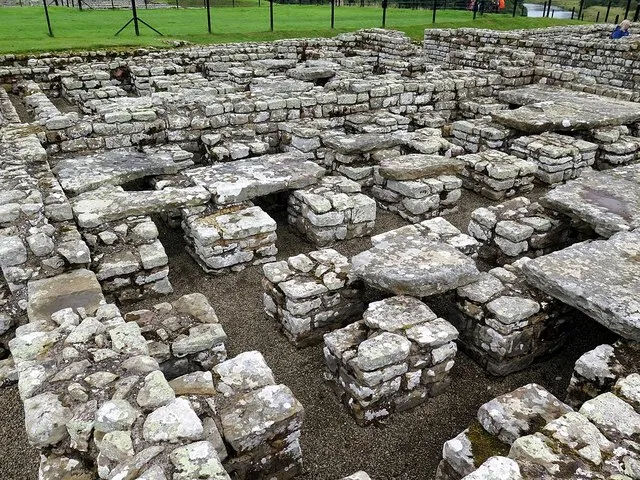
Short stacks of stone holding up a stone floor, in the ruins of a building
Under-floor heating in the commanding officer’s house. Hot air from a furnace flowed between the stacks and warmed the floor above.Photo: Andrew Curtis, CC BY-SA 2.0, via Geograph
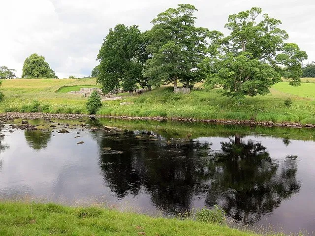
A calm river with trees on the far bank and grass in the foreground
The North Tyne, from the east bank by the remains of the Roman bridge. The bridge’s abutment on the fort side is now under the water.Photo: Andrew Curtis, CC BY-SA 2.0, via Geograph
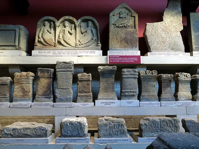
Shelves of carved stone altars and reliefs in a museum
Altars and carvings in the Clayton Museum at Chesters, opened in 1896 to hold what John Clayton found along the Wall.Photo: Andrew Curtis, CC BY-SA 2.0, via Geograph
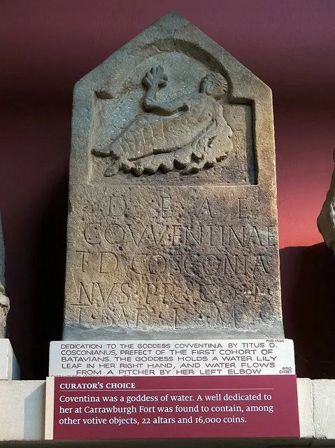
A carved stone slab with a reclining goddess at the top and a Latin inscription below
A dedication to the water goddess Coventina, from her sacred well at the fort of Carrawburgh, now in the Clayton Museum.Photo: Andrew Curtis, CC BY-SA 2.0, via Geograph

Sources for this page

Every number on this page comes from one of these. How we check.

Last reviewed 12 November 2026. Spotted a mistake? Tell us.

  1. Hodgson, N. History of Chesters Roman Fort. English Heritage. (Principal Keeper of Archaeology, Tyne & Wear Archives & Museums.) www.english-heritage.org.uk/visit/places/chesters-roman-fort-and-museum-hadrians-wall/history/Used for: Chesters: the cavalry units, the bridge, the bath house and John Clayton. Checked 12 November 2026.
  2. Pleiades: a gazetteer of past places. Institute for the Study of the Ancient World, New York University. CC BY 3.0. pleiades.stoa.orgUsed for: Roman names of places and their positions. Checked 12 November 2026.
  3. Natural Earth, 1:110m and 1:50m land, public domain, via the world-atlas package by Mike Bostock (ISC licence). www.naturalearthdata.com/Used for: Every coastline drawn on this site. Checked 11 November 2026.