Port and fort · Kent, England

Richborough

Roman name: Rutupiae

Two thousand years ago this was a small island on the Kent coast. The Roman conquest probably began here, and a white marble arch twenty-six metres tall told every traveller they had reached Britain.

LondonWroxeterBathYorkVindolandaCorbridgeChestersHousesteadsBirdoswaldPortchesterRichborough
Other dots are the places we cover. Wall lines simplified. Coast: Natural Earth.
Roman from
AD 431
Arch
about 26 metres tall2
Town
at least 21 hectares
Last contact
early 5th century
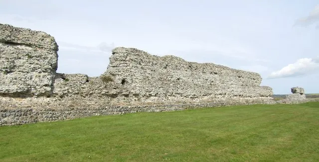
A long, high ruined wall of flint and stone across a mown field
The west wall of the stone fort, built about AD 275 to 290 after the town and its arch were partly pulled down.Photo: Colin Smith, CC BY-SA 2.0, via Geograph

The story of Richborough

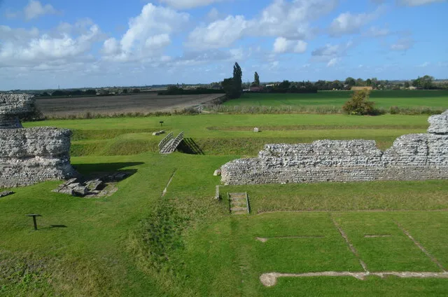
Richborough now sits two miles inland, in the marshes of east Kent. In Roman times it was a small island at the south end of the Wantsum Channel, a sea passage up to two miles wide that cut the Isle of Thanet off from the rest of Kent. A shingle bank sheltered the channel from the open sea, making a safe harbour at the end of the shortest crossing from Gaul.1

The landing

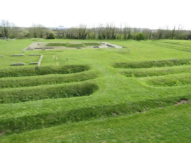
In AD 43 the emperor Claudius sent about 40,000 men to conquer Britain: four legions of about 20,000 heavy infantry, and as many auxiliaries again, including cavalry. They may have needed 700 to 1,000 ships.3 Here at Richborough the army dug two deep, parallel V-shaped ditches with a rampart, at least 650 metres long, to guard a beachhead for ships, troops and supplies. The army met no resistance in east Kent and marched inland, and Richborough became its supply base.1

Where experts disagree

Did the army land here?Most historians think so. The crossing is much shorter, the winds and tides easier, and the Claudian ditches here look like a beachhead. From here, the army could march along the North Downs, cross the Medway and the Thames and take Colchester.3

Or at Chichester?There is early Roman military evidence near Chichester Harbour too, in the lands of the Atrebates, a British people friendly to Rome. A landing there might have been meant to restore their kingdom first, after its pro-Roman king had been driven out. The few written accounts do not settle it.3

The gateway to Britain

Around AD 90 a vast four-way arch went up above the shore, about 26 metres tall and clad in white marble from Carrara in Italy, a stone that could be used only with the emperor’s permission. It weighed about 20,000 tonnes and stood on a foundation 9 metres deep. Ships could see it for miles, and for many travellers it was their first sight of Britain. Watling Street started at its foot and ran to London and on across the Midlands to Wroxeter, about 250 miles away.2

The town around it was at its best in the 2nd century, with a stone inn for officials on government business, shops along the streets, and an amphitheatre with an arena 62 by 50 metres, where up to 5,000 people might have watched beast hunts, fights and executions. Digging there in 2021 found the arena wall had been plastered and painted.1

The last fort

Around AD 250, with raiders in the Channel and wars inside the empire, the centre of the town was cleared for a small fort. Soon after AD 275 a much bigger stone fort replaced it, one of the chain now called the Saxon Shore forts. To make room the arch was pulled down, and most of its marble was burnt to make lime for the mortar of the new walls.12

The town lived on outside. Richborough may well have been the last place in Britain to which Roman coins were sent, so the Roman story both begins and ends here.1
The arch, measured

What stood, and what is left underfoot.

gonefoundation, still thereRoman ground0 m5 m10 m15 m20 m25 m−9 ma person

The arch stood about 26 metres high, roughly fifteen times the height of a grown person.2

All that survives is its foundation, 9 metres deep, and the cross-shaped pavement on top where two roads met beneath the four archways. For centuries visitors could not tell what it was: a lighthouse, a signal tower, even a winch for hauling ships ashore. In 1968 Barry Cunliffe suggested a four-way arch, and Gerald Strong worked out its height from the fragments.2

The arch drawn as a column at true scale, 26 metres above the Roman ground and 9 metres of solid foundation below it, beside a person 1.7 metres tall. Its width and decoration are not drawn, because they are less certain.

Richborough through time

From beachhead to farmland.

  1. AD 43Invasion Ditches dug to guard the beachhead.
  2. AD 90Arch built Around AD 90; some think as late as 150.
  3. AD 250Small fort The town centre cleared.
  4. AD 280Stone fort Between AD 275 and 290; the arch pulled down.
  5. AD 950A church Probably 10th century, in use until the late 1600s.
  6. AD 1849Arena dug First excavation of the amphitheatre.
  7. AD 1968Arch explained Barry Cunliffe: a four-way arch.
  8. AD 2021New dig The painted arena wall found.
Dated events only. Red: Roman. Black: after Rome. Spacing is true to time.

What is there today

Photographs by visitors, shared under an open licence.

Grassy parallel ditches curving across a field inside ruined walls
Ditches inside the fort walls. The earliest, two parallel V-shaped ditches, protected the invasion beachhead of AD 43.Photo: Colin Smith, CC BY-SA 2.0, via Geograph
A ruined fort wall with flat farmland stretching away behind
The Saxon Shore fort wall, with the flat land that was once the Wantsum Channel. The sea is now two miles away.Photo: Rod Grealish, CC BY-SA 2.0, via Geograph

Sources for this page

Every number on this page comes from one of these. How we check.

Last reviewed 12 November 2026. Spotted a mistake? Tell us.

  1. History of Richborough Roman Fort and Amphitheatre. English Heritage. www.english-heritage.org.uk/visit/places/richborough-roman-fort-and-amphitheatre/history-and-stories/history/Used for: Richborough: the landing of AD 43, the coastline, the port, the amphitheatre and the Saxon Shore fort. Checked 12 November 2026.
  2. Gateway to Britannia: Richborough’s monumental arch. English Heritage. www.english-heritage.org.uk/visit/places/richborough-roman-fort-and-amphitheatre/history-and-stories/gateway-britannia/Used for: The four-way marble arch: size, weight, foundation and the debate over its date. Checked 12 November 2026.
  3. The Roman invasion of Britain, AD 43. English Heritage, Story of England: Romans. www.english-heritage.org.uk/learn/story-of-england/romans/invasion/Used for: Why Claudius invaded, the size of the army, and the debate over where it landed. Checked 12 November 2026.
  4. Pleiades: a gazetteer of past places. Institute for the Study of the Ancient World, New York University. CC BY 3.0. pleiades.stoa.orgUsed for: Roman names of places and their positions. Checked 12 November 2026.
  5. Natural Earth, 1:110m and 1:50m land, public domain, via the world-atlas package by Mike Bostock (ISC licence). www.naturalearthdata.com/Used for: Every coastline drawn on this site. Checked 11 November 2026.